Back to Markwell Website Home


Adding "Additional Waypoints" to existing caches? CLICK HERE
I received a GPX file (from a Pocket Query or from the cache page) and it has a separate file. What is this, and how do I use it? CLICK HERE
| Back to the FAQ Back to Markwell Website Home |
| For the basics of Additional Waypoints CLICK HERE Adding "Additional Waypoints" to existing caches? CLICK HERE I received a GPX file (from a Pocket Query or from the cache page) and it has a separate file. What is this, and how do I use it? CLICK HERE |
 Here are step by step instructions for placing Additional Waypoints on your cache page:
|
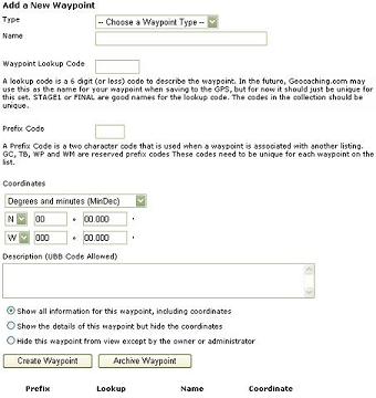 Next is an entry field for a waypoint lookup code. As it says on the Waypoint Collection page, STAGE2 or FINAL are good names for the lookup code. You may use anything you want, but each entry must be unique - you cannot have two waypoints with STAGE2 as the lookup code.
|

| Do you own multistage or mystery/puzzle caches that were published more than five or six months ago? If so, the parking, intermediate and final stage coordinates may be in reviewer notes, e-mail messages you sent to the person who was your reviewer at the time, or perhaps just in your personal notes if the cache was published before 2003-2004 when we started looking beyond the coordinates at the top of the cache page. There's now a new feature on your cache page - a way to document the waypoints associated with your cache, in addition to the obvious posted one. You can add waypoint coordinates to help other geocachers - like a parking area or a trailhead. For the paperless caching crowd those additional waypoints can be magically downloaded to a PDA and GPS. Pretty cool. You can also add coordinate waypoints to help us - your cache reviewers. That would include the final coordinates of a mystery cache, and the intermediate and final coordinates of a multistage cache. This category of added waypoints can be set to be only be visible to you and to an administrator/reviewer like myself using a new reviewer’s tool. While having your coordinate information documented with your cache page can be helpful to you, your reviewers will probably gain the greatest benefits. And what helps your reviewers also helps you, but we will get to that a little later. Here's why we ask that you do this: Whenever we review a new cache submission we have to be sure that it's not too close (less than .1 mile, or 528 feet) to another cache, or to the intermediate stages of another cache. We are not so concerned with the ficticious posted coordinates of a mystery cache, but we don't want your container being found while someone is searching for another one. When a new cache is submitted in a cache-rich area we have to check for the nearest caches, then open as many as a dozen nearby cache pages, retrieve that "note to reviewer" and compare the new cache's coordinates to those of the old cache. It's very tedious and time consuming. The "waypoints" feature has been added to help the cache reviewers. With this plus a new reviewer tool, we can click on a link that will show the reviewers at a glance how close the new cache is to the starting and ending coordinatess of all other caches in the area. It's a great help, but it relies on those waypoints being recorded to provide a comprehensive view. So how does this help you as a cache owner? First, it provides you with a convenient place to store the details of your multistage and mystery caches. No more random scraps of paper or extra waypoints stored on your GPSr. Second, it will help prevent cache placements that conflict with or overlap one another. Third, it will help the volunteer reviewers perform a more thorough assessment of potential cache proximity issues. Fourth, it will help to get new caches published more promptly for you to hunt. (OK; this one is a bit lame, but I needed to say someting to make you smile at this point.) If you could help us out by updating your previously published caches, it will be greatly appreciated. Thank you. -gpsfun, MadMin, and POFE Volunteer Reviewers for New England (With thanks to erik88l-r for his similar article in the GGA forums.) |
 I received a GPX file (from a Pocket Query or from the cache page) and it has a separate file. What is this, and how do I use it?
The Additional Waypoints, as illustrated above, can serve many purposes. One is to show stages of a multi-cache to a reviewer, but another use is for parking coordinates, trail heads, points of interest, etc. If cache owners have put this information into the system, when you get a GPX file from Geocaching.com, it will have TWO files - one of JUST the cache data, and a second of these Additional Waypoints. The WinZip file to the right has additional waypoints. The file contains one file that has a numeric name and an extension of GPX. The second file is the same number, along with -wpts and the extension of GPX. The one with the -wpts is the file containing these additional waypoints. |
 If you open this second file in EasyGPS or GSAK or Watcher, it will act like a regular file with a bunch of waypoints, ready to load into your GPS. The problem with EasyGPS, is that there's no way to tell which parent cache these "child" waypoints belong. GSAK does a pretty good job of matching them up, though. If you open this second file in EasyGPS or GSAK or Watcher, it will act like a regular file with a bunch of waypoints, ready to load into your GPS. The problem with EasyGPS, is that there's no way to tell which parent cache these "child" waypoints belong. GSAK does a pretty good job of matching them up, though. |